
Washington, D.C. — Fall may be arriving on the calendar, but for much of the United States, summer-like warmth could linger well into the season.
A new seasonal outlook from the National Oceanic and Atmospheric Administration (NOAA) is pointing toward a predominantly warmer-than-normal fall, while a strengthening El Niño could play an increasingly important role in weather patterns heading toward winter.
The outlook covers September through November, giving Americans an early look at what forecasters expect for temperatures and precipitation across the country.
Most of the Country Could See a Warmer Fall
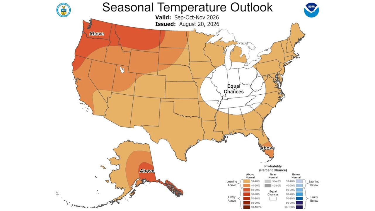
NOAA’s Climate Prediction Center expects most states to lean toward above-average temperatures this fall.
The strongest signal for warmer weather appears in the Pacific Northwest, where forecasters say above-normal temperatures are particularly likely.
That could mean summer-like conditions linger longer in some areas even as shorter days and cooler nights signal the transition into fall.
However, the forecast is not equally confident everywhere.
Illinois, Indiana, Kentucky, Missouri, Ohio, Tennessee and West Virginia are among the states where NOAA sees roughly equal chances of a warmer-than-normal, cooler-than-normal or average fall.
In other words, residents in those areas may have to wait longer before the seasonal pattern becomes clearer.
Rainfall Forecast Is Much More Uncertain
The precipitation outlook is considerably less certain across the country.
According to NOAA, portions of the Southwest and Southeast have better odds of seeing above-average precipitation between September and November.
Meanwhile, the Northeast and Pacific Northwest are more likely to experience below-average precipitation.
For much of the rest of the country, forecasters are not favoring one outcome strongly enough to make a confident prediction.
Many states have roughly equal chances of receiving below-average, average or above-average precipitation. That uncertainty means local weather could vary considerably even within the same broad region.
Hawaii Could Follow a Different Pattern
Hawaii has a separate outlook from the mainland.
NOAA says Oahu, Maui, Kauai and the Big Island are more likely to experience above-normal temperatures during fall.
However, the islands could see a significant change as winter approaches.
Forecasters expect conditions to shift toward cooler weather in early 2027, while the chances of below-normal precipitation increase across Hawaii beginning in October.
El Niño Could Become a Major Weather Driver
One of the biggest factors behind the evolving forecast is El Niño, which has been strengthening since it officially developed earlier this summer.
National forecasters now estimate that the odds of the 2026-2027 El Niño reaching the strongest category, sometimes referred to as a “super” El Niño, are above 90%.
The phenomenon is expected to reach its maximum strength in late fall or early winter, when its influence on atmospheric circulation could become most pronounced.
What El Niño Could Mean for the U.S.
El Niño often produces a recognizable pattern across North America.
Historically, it can bring warmer and drier conditions across northern parts of the country and the Ohio Valley, while the southern United States tends to experience a wetter pattern during winter.
The exact boundary between those regions can shift from year to year depending on the position and strength of the jet stream.
Some early hints of that pattern may already be visible in NOAA’s fall outlook, particularly with warm and dry conditions favored in the Pacific Northwest and wetter conditions expected in parts of the South.
El Niño can also influence other weather hazards. It typically suppresses Atlantic hurricane activity, while potentially contributing to an increased risk of high-tide flooding along the West Coast.
With the climate pattern expected to strengthen further, forecasters will continue watching how it interacts with the jet stream and other atmospheric conditions as fall approaches.
What kind of fall weather are you expecting in your area — warmer, wetter or cooler than usual? Share your thoughts in the comments below.